Research Update: Visualizing Thermal Disparities
The LAF Research Grant in Honor of Deb Mitchell supports research relevant to design practice. In 2023, the $25,000 was awarded to Salvador Lindquist and Keenan Gibbons to fund an 18-month project beginning in June 2023. Six months into the project, they provided an update and compelling images illustrating their progress.
Their research project, Heat Waves: Visualizing Thermal Disparities is collecting and analyzing temperature data for Omaha, Nebraska, using commercially available thermal visualization tools in order to evaluate the positive impacts of nature based solutions on mitigating extreme heat. Salvador Lindquist (University of Nebraska - Lincoln) and Keenan Gibbons (SmithGroup/University of Michigan) believe visualizing heat disparities is a form of recognition of the disproportionate impacts heat has on vulnerable populations. They see images and maps as tools with the potential to enact positive change by revealing unjust systems and lived realities. Equitable access to shade and comfortable microclimates are often perceived as an amenity, but should be considered a public health concern. High quality visual data can make the distribution of extreme heat more tangible and aid in consensus building across disciplines and policy makers.
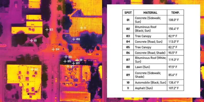
The prevailing method of visualizing heat in landscapes is Land Surface Temperature (LST), which is measured using United States Geological Survey (USGS) remote sensing data from Landsat, a series of satellites orbiting the earth. They capture raster-based images, which are then stitched together before being published on the USGS website. However, these images can only reach a resolution of 30m x 30m. According to Salvador and Keenan, this data works well at a city or regional scale but doesn’t serve the needs of landscape planners and policy makers designing more just and equitable cities because it overlooks the lived reality of heat. More granular thermal visualization methods are needed.
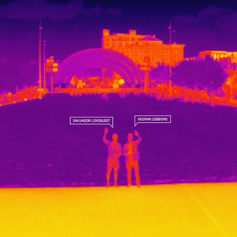
Using funding from the LAF Research Grant in Honor of Deb Mitchell, Salvador and Keenan are cataloging alternative ways to visualize the localized impacts of heat, including the use of drones. Drones have become more and more accessible over the last few years and can capture high resolution images as well as infrared thermography, allowing the researchers much more specific data, even to the point of pinpointing specific material temperature.
While these high-resolution images from the drone are great at providing better detail from above, they still miss the on-the-ground impacts of heat. So the researchers have supplemented drone data with handheld tools, including a thermal camera, temperature gun, and heat stress tracker. The handheld images and data allowed them to target specific landscape interventions and study their potential for heat mitigation (or contribution to the heat island effect).
Their research will conclude in fall 2024. The primary output for this project will be a toolkit for landscape planners and policymakers to make better-informed decisions in designing more just and equitable cities by using thermal visualization tools to show positive design impacts at a level that is more granular and reflective of the lived experience of extreme heat in formerly redlined communities. Outputs will also support the City of Omaha’s climate action and resilience plan.
In September, the team and their work was featured on The Weather Channel. Additionally, the Heat Waves team has connected and begun collaborating with LAF Fellow Kimberly Garza and her Cool Conscious Cities project. Updates on Heat Waves are being posted on the @cool_conscious_cities Instagram. You can also follow their work on Instagram at @salvador.lindquist and @keenan.gibbons.
Stay tuned for a LAF webinar on their findings in fall 2024.